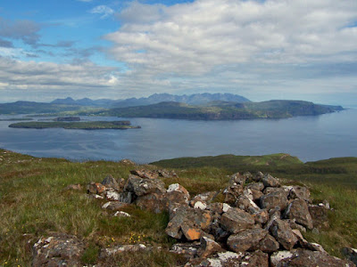
The purpose of this blog is to publish some of our pictures of the Isle of Skye, Scotland. We lay no claim to these being great photographs - they are just pictures of what we see, taken with ordinary compact cameras. We hope you enjoy browsing.

Richard and Sue


(CLICK ANY PICTURE TO VIEW A FULL-SIZE GALLERY)


Saturday, 31 December 2016

Skye Roads

How do we get about, up here in the Far North? Well, it's not all dark ages. Running the length of Skye, from the Bridge at Kyleakin in the south east, to the Outer Isles ferry terminal at Uig in the north west is the A87. A fine, two-way traffic road full of sweeping curves, wonderful views and a few potholes. Leading off the A87 is the A851 to Armadale in the south, and the A863 and A850 which loop to Dunvegan in the west. These are also two-way roads, also with sweeping curves and wonderful views, plus rather more potholes - but still offering good routes around the island. Then there's the A855 to Staffin in the north east. This busy-in-summer road still has sections of single track, so can be a bit tiresome to drive along in peak tourist season, though you get plenty of time to admire more wonderful views - which on this road are awesome.

Everywhere else is served by single track roads, usually dotted with frequent passing places. The primary purpose of these roads (apart from providing a firm surface across the moor for the locals to drive over) is to test the summer visitor's nerves and ability to reverse their rental car or motor caravan. When meeting an oncoming vehicle, it is NEVER a good idea to drive off the road onto the verge. The verges are ALWAYS boggy, and you may have to wait quite a while for someone in a 4x4 who is carrying a tow-rope to happen along and pull you back onto the road. By then, you will probably discover that on leaving the firm surface, you shredded the inside sidewalls of one or even two of your tyres on the frequently razor-sharp edge of the tarmac.

Incidentally, single-track roads almost always finish at a dead end. This feature provides visitors with a further opportunity to practice their reversing skills - and then you have the fun of retracing your route to the main road you left some dozen or so miles before.

I have rummaged in my photo archive again, and offer for your perusal, a selection of Skye Roads photos in no particular order. Enjoy!

A863 towards Sligachan

A863 towards Dunvegan

A87 approaching Portree - note the 'normal' Skye winter weather...

Single-track road to Glendale from Dunvegan.
This is the only straight bit - after this it's a dozen or more tortuous miles to the popular Neist Point - busy in summer

Single track through Dunvegan Woods - this road leads to the popular 'Coral Beach'

A855 passing Storr Lochs - single track section. The road was being re-surfaced. Yes - that IS a sheep on the road.

A87 towards Sligachan

Single track towards Orbost

A87 towards Sligachan

Totaig (near Dunvegan). It's an interesting challenge to turn left off the 'main' road onto the 'minor' one!

The road to Bay

A87 entering Dunan (near Broadford)

A87 towards Sligachan

Typical spring hazard at Coillore - ewe and lamb about to attack photographer

The Hill Road from Portree to Struan. Built by Skye crofters as a joke - the tourist's Sat Navs send them all down this route as it is slightly shorter than using the main roads. Great fun watching the camper vans trying to reverse when they meet another one coming the other way.
A855, single track section approaching The Storr

By the way - have you noticed the complete lack of traffic in these pictures? They are nearly all taken in winter... It can get a wee bit busier in summer!

Wednesday, 21 December 2016

Skye White Christmas

OK  - I'm cheating. It isn't quite Christmas 2016 yet, and it doesn't look too much like it will be a white one here at Roskhill. But we do get some snowflakes here from time to time, so in the seasonal spirit of ''White AT Christmas", here are a few of our archive pictures of snow on Skye...

Roskhill before the re-build. I love our glowing living-room window!

A view from Roskhill Barn...

...and another view from Roskhill Barn

Sgurr nan Gillean

Marsco

MacLeod's tables from A863, Roskhill

Ben Tianavaig from The Braes 

Take Cover! Snow shower approaching over the moor

The Cuillin over Gesto Bay

The Cuillin over the old bridge at Sligachan

Healabhal Mhor from Roskhill

A863 near Roskhill

Saturday, 19 November 2016

Skye Falls

Being a hilly place with lots of rain, one can reasonably expect Skye to have a large number of rivers. As it happens, because Skye isn't all that big, and mostly slopes quite steeply, the natural drainage tends to take the form of many small gushing streams (called burns here) rather than wide lazy rivers. At times of heavy rainfall, water levels can rise quickly and dramatically. Here, as an example, are two pictures of our local burn (which is actually called a river...) taken from about the same vantage point...

Roskhill River - at a trickle...
... and in spate
Often, the burns cascade over exposed bedrock and 'rapids', and some occasionally plunge over precipices in the form of waterfalls. Some of Skye's most dramatic waterfalls occur at the coast, where burns throw themselves over the cliffs to the sea below. These can be even more dramatic in a storm when the wind blowing the falling water back over the clifftop creates an upside-down waterfall! Unfortunately, most of the coastal falls can only be seen from afar, or from the sea itself. The majority of our inland falls are relatively small affairs. Here's a few from my photo archive...

River Logasdal - and some of the best coastal scenery on Skye - Duirinish
Allt Mhicheil, Duirinish - would look amazing when in spate!
Allt Mainnir nan Gobhar, Waternish
Over the Edge - I am standing IN the burn at the top of a cascade into the sea below

Dibidal River, Duirinish

Dibidal River reaches the sea

Red Burn, Greshornish
Ramasaig Bay
Allt Coir' a' Mhadaidh - Skye's infamous Fairy Pools river
At 80 feet - Skye's highest inland fall - Eas Mor, in Allt Coire na Banachdich

Tuesday, 8 November 2016

NW Skye's Beaches

Friends on holiday in Cornwall have recently sent me a couple of photos of their walks on beautiful sandy beaches. That set me thinking - about beaches on Skye...  Well, in spite of Skye having a very long coastline, we have very few sandy beaches here. In places, especially in the north of the island, the land ends abruptly at a sheer cliff (the highest clifftops on Skye tower some 1000 feet above the water below). In most other places, the shore is rocky and inhospitable - not an easy place for a leisurely stroll.

I have searched my photo collection and come up with pictures of some of the beaches in our local area...

Bharcasaig - a small beach of black basalt sand at low tide
Coral Beach at Claigan.
The beach is not sand or coral - it is actually a material called maerl -
dead fragments of a hard seaweed, crushed by the waves and bleached by the sun
Diubaig - a dramatic but difficult-to-get-to beach of black basalt pebbles
Galtrigill - a small, rocky and almost-never-visited beach on Loch Dunvegan
Flat bare rock at Greep
SAND! (but only at low tide) - shore of Loch Losait, near Gillen
Ramasaig Bay - another rocky shore
Un-named beach of rocks and pebbles near Trumpan

Wednesday, 19 October 2016

Skye High

This post is of some of the summit views I have photographed from the hills that surround us at Roskhill. The highest is Healabhal Bheag at just 488 metres... so no great feats of mountaineering required to reach these peaks - mostly just a slog through bog and heather - but still a huge sense of achievement for 'getting to the top' ... and just imagine the silence...!

(Throughout this blog - click on any picture to view a larger-size gallery)

Healabhal Bheag (Highest point in NW Skye)
Beinn na Boinead
Ben Idrigill
Beinn Bhreac
Ben Ettow
Beinn na Boineid (again)
Beinn Bhac-ghlais
Ben Idrigill (again)
Healabhal Mhor
Beinn an Fhraoich
Ben Horneval